Policies which set out how land is used form the backbone of any
Neighbourhood Plan
The final policies adopted for the Rame Peninsula will be influenced by what local residents are telling us.
As the consultation process progressed, policy themes emerged.
16 Policies have been drafted
Policies 1 – 10 are policies for the whole Rame Peninsula.
Policy numbers 11 – 16 are specific to individual parishes.
The Policies
Rame NDP Policy 1: New Housing – Primary Residency
Policy: Planning permission for new dwellings (excluding replacement dwellings), within the Rame Peninsula NDP area, will only be permitted where they are to be occupied as a principal residence.
Reason: The Rame Peninsula Neighbourhood Plan has evidence that the combined problems of affordability, second home ownership and environmental constraints for local residents justifies a special approach.
Rame NDP Policy 2: Community Infrastructure Levy
(Local Element)
Policy: Developers of housing and employment sites, within the Rame Peninsula NDP area, will be required to contribute to Highway Infrastructure Improvement Projects, via the Community Infrastructure Levy and as identified in the Rame Peninsula NDP Local Infrastructure Schedule.
Reason: The Rame Peninsula has seen many years of development without any significant improvement to the local highway infrastructure. Congestion causes unreliable journey times that affect residents and more particularly businesses
requiring delivery by large vehicles; this reduces the quality of life for residents and restricts economic development.
Rame NDP Policy 3: Renewable Energy
Policy: Renewable Energy Schemes, (including Wind and Solar), within the Rame Peninsula NDP area, must not have an unacceptable impact on the character and appearance of the immediate and wider landscape, and of areas of natural,
cultural, historical or architectural interest.
 Reason: There is a great deal of support on the Peninsula for a green future, both in terms of energy efficiency and generation. However local opinion does indicate concern that the encouragement of large-scale renewable energy schemes is overwhelming the consideration of the Peninsula’s unique environment,
demonstrated by the very large number of designated areas. These designated areas are diversely located around the Peninsula but planning consideration should be given to the Peninsula as a whole. Concerns cover landscape and heritage, as well as local environmental factors such as noise etc. Whilst there is some protection in respect of specific designations in the Cornwall Local Plan, recent planning applications have indicated a need to further define policy in order to enable appropriate development that does not pose risk to the local environment of the whole Peninsula.
Rame NDP Policy 4: General Development
Policy: Development will not be permitted, within the Rame Peninsula NDP area, unless the infrastructure and community facilities needed to serve it either
adequately exist in advance or will be provided as part of the development.
Where a development would displace or harm a feature of special conservation or amenity value, suitable offsetting measures, within the Rame Peninsula NDP area, may be required.
Reason: The Rame Peninsula NDP area is a geographical peninsula bordered by 24 miles of coastline and only one mile of land adjoining the rest of Cornwall.
Although located in close proximity to Plymouth and Saltash, in reality the
peninsula is very self-contained as to access these larger settlements involves either a ferry or an 18 mile journey.
The nature of the peninsula means that access is constrained and it has poor infrastructure and facilities to serve the needs of the communities.
Rame NDP Policy 5: Flood Risk Management
Policy: Development will not be permitted, in the Rame Peninsula NDP area, where it would:
a) be at risk from alluvial or coastal flooding, or;
b) increase the risk of flooding by:
i. reducing the capacity of the floodplain, or;
ii. through the discharge of additional surface water, or;
iii. harming flood defences, or;
iv. obstructing the safe passage of flood flows.

Reason: The Rame Peninsula has numerous flood zones, both 2 and 3. The Environment Agency sets out its own criteria on what development might be permitted in these areas. This policy helps to support current flood management measures and to enhance them given
historical flooding issues within settlements in the NDP area.
Rame NDP Policy 6: Conservation Areas
Policy: All proposals for development in Conservation Areas must pay special
attention to the desirability of preserving or enhancing the character or appearance of the area.
All development (including new buildings, extensions, hard surfaces, walls and landscaping) should be sympathetic in size, scale, height and materials to the
historic character of the particular Conservation Area and the vernacular tradition of its architecture.
Reason: The Conservation Areas within the Rame Peninsula NDP area are highly valued by the community and are important to the fabric and landscape of this sensitive area.
Rame NDP Policy 7: Development In The Rame Peninsula NDP area
Policy: The whole of the Rame Peninsula is designated as either an ANOB or an AGLV and development will not be permitted unless the development:
a) is sited to minimise its visual impact on the landscape;
b) is consistent with the character of the particular area in which it is sited;
c) is designed so as to reflect locally distinctive character, traditional building styles and local materials;
d) conforms with the locally characteristic patterns of settlement where it is sited;
e) does not materially affect the views to or from historic monuments and or listed buildings.
Reason: The landscape, coastline and wealth of historic monuments and grade listed buildings in the Rame Peninsula, which if protected, provide a unique
attraction for tourists and for use by residents and those living in the immediate area and adjacent in more densely populated areas, to enjoy and appreciate.
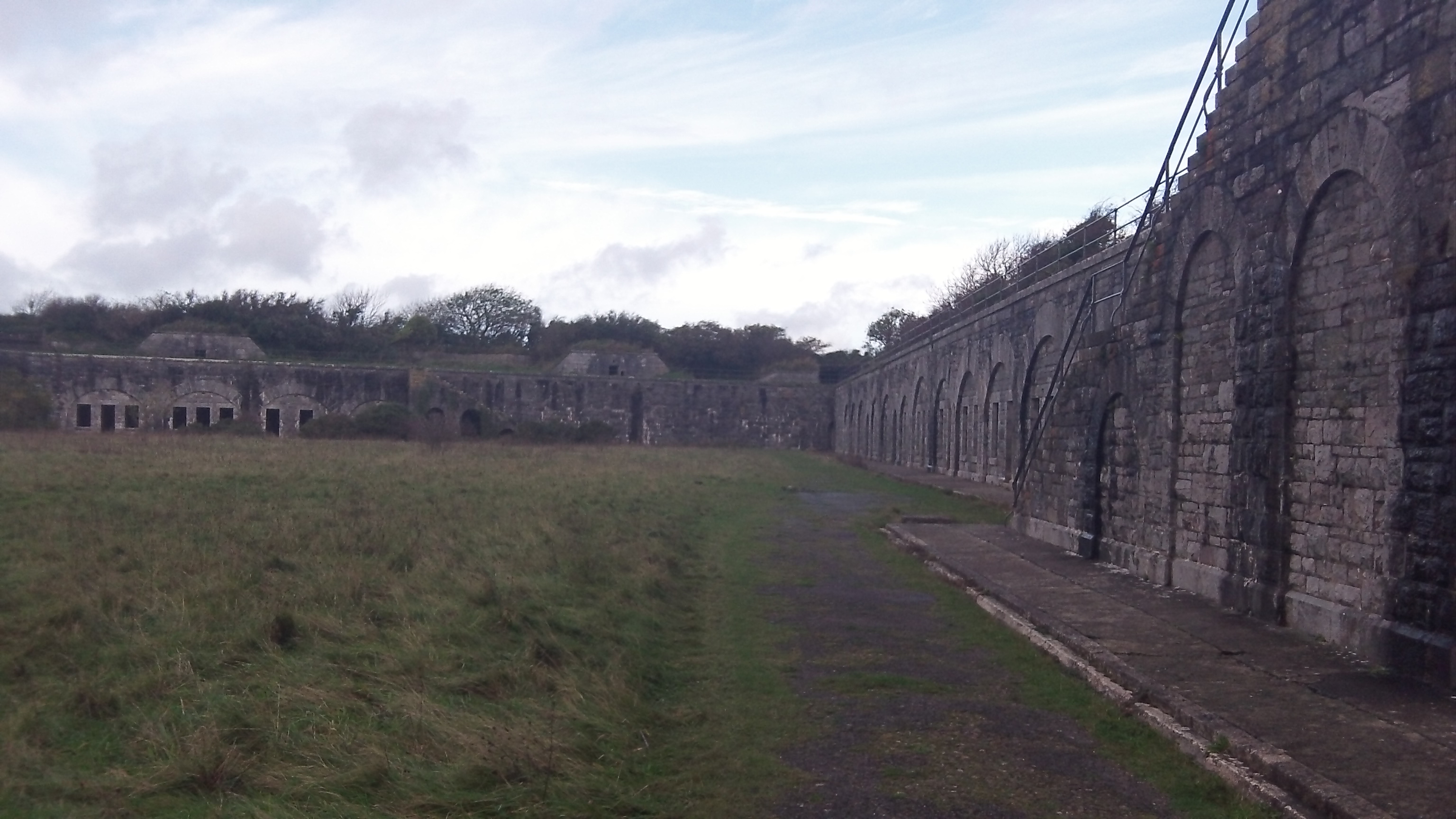
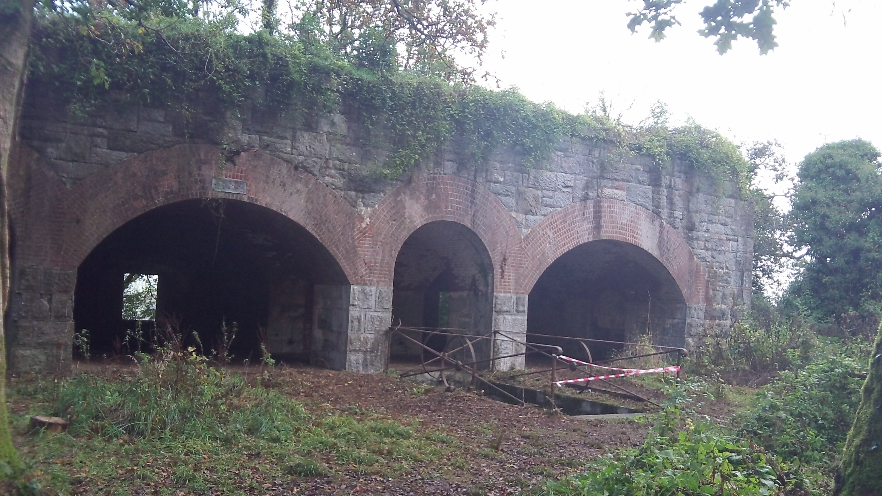
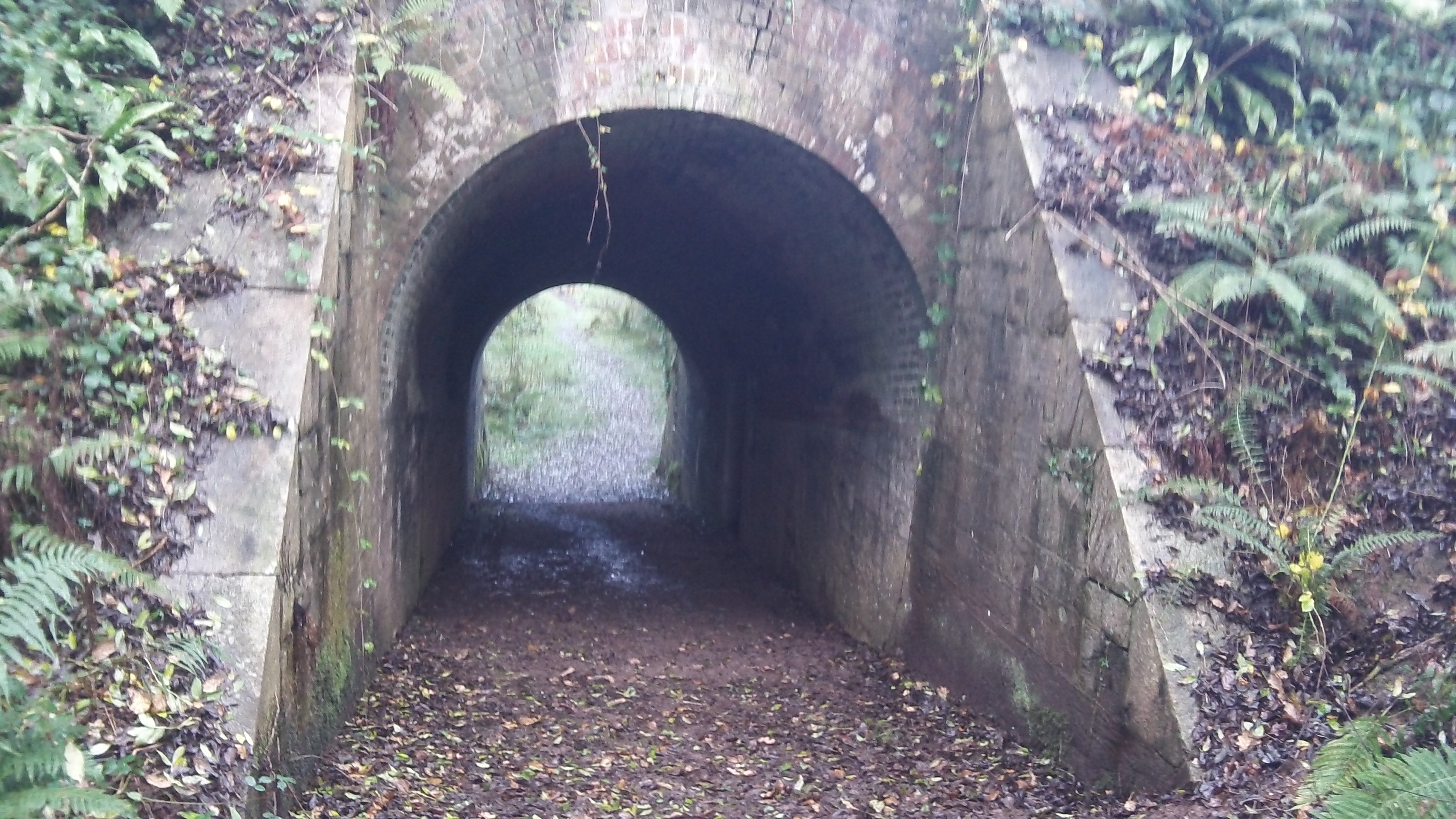
Rame NDP Policy 8: The Forts of the Rame Peninsula
Policy: High priority must be given to the protection, preservation, access and enhancement of nationally important scheduled and unscheduled monuments and other sites and buildings of archaeological and historic significance in the NDP area.
Reason: The Rame Peninsula has one of the most impressive collections of
nationally important historic forts in the UK. This policy helps to ensure that these buildings and other sites of archaeological importance are preserved.

View information on these historic forts and Plymouth Historic
& South Hams historic defences by clicking this link
PlymouthHistoricDefencesManagementAppraisal


Kingsand-and-Cawsand-Conservation-Area-Appraisal-Draft
Rame NDP Policy 9: Mount Edgcumbe Country Park
Policy: Proposals for development affecting the park and gardens will not be approved unless all the following criteria can be satisfied:
(i) that the important historic and architectural features, layout and ornamentation of the gardens are protected, preserved and enhanced;
(ii) that the character of the parkland setting is preserved or enhanced; and,
(iii) that trees and woodland that contribute towards the character of the historic gardens are retained.
Reason: Mount Edgcumbe Country Park is a Grade I historic parkland set within 865 acres on the Rame Peninsula. It is the largest Country Park in England. It is highly valued both nationally and locally and provides employment and tourism within the area. This policy is required in order to ensure this valuable asset is maintained and enhanced.
 Mount_Edgcumbe_vision_and_action_plan
Rame NDP Policy 10: Maker Heights
Policy: Development will be supported that:
a) protects, preserves and enhances the significant built, natural and landscape heritage of the locality, in accordance with existing landscape and built heritage policies and designations; and,
b) continues to support significant levels of:
i. public access; and,
ii. local enterprise opportunities, specifically, but not exclusively focused around cultural, tourism and knowledge economy sectors, especially where they have significant benefit in terms of provision of local services and economic impact (i.e. jobs).
Sympathetic private, holiday or residential development may also be considered but only where this would specifically support long-term sustainable open-access and economic opportunity.
Reason: Maker Heights is an important location within the Rame Peninsula. It is seen as a valuable community asset and is the location of many scheduled monuments and listed buildings. This policy seeks to preserve and enhance the site whilst enabling some level of economic growth and job creation in this sensitive area.
For detailed evidence see Section 2 of the Rame Peninsula NDP Evidence Summary.
Village specific policies
Millbrook
Rame NDP Policy 11: Commercial Growth area for Millbrook
Policy: Within Millbrook Parish, industrial and/or business development (including small workshops) that encourage the movement of HGV and large vehicles must be located in close proximity to Gallows Park Industrial Units.
Reason: One of the major problems on the Rame Peninsula as a whole is the road infrastructure. The general feeling is that the road system is inadequate to support any further development, be it housing or commercial. That said, there is the need for economic growth in Millbrook and the Peninsula as a whole and it is felt that the sites at Gallows Park/ Millbrook Business Park, as they are situated before the actual village, would be the best place for any industrial/commercial/ business units in order to prevent the need for more heavy traffic to travel down the narrow road between Gallows Park and the village or to enter the village itself.
For detailed evidence see Section 2 of the Rame Peninsula NDP Evidence Summary.
Rame NDP Policy 12: Millbrook Lake and Green Space
Policy: Millbrook Lake and its surrounding green area, including the playing fields, must be protected and enhanced as a public open space and amenity area.
Reason: The lake and the surrounding area is a very popular and well used amenity in the village. Local people take great enjoyment in walking around the lake, observing the wildlife in the area, boating, model boats, dog walking, jogging etc. Very prized facility and locals are, rightly, very proud of “their” lake.

Rame NDP Policy 13: Southdown & Foss Quay Boatyards
Policy: The development of workshops on the site of the Southdown or Foss Brickworks for B1 and B2 uses will be permitted for small boat landing facilities and leisure moorings; heritage interpretation and amenity planting, provided that the proposals do not:
a. add to difficulties with water supply, sewerage and sewage treatment and water disposal;
b. have a materially adverse impact on the village or rural environment in terms of visual appearance, noise, effluent or fumes it would emit, or traffic it would generate;
c. have a materially adverse impact on nature conservation or the landscape;
d. have a materially adverse impact on existing businesses located in the area.
Reason: The two brickworks lie at some distance to the east of Millbrook, and have direct access to the tidal Millbrook Lake. Though road access has been partially improved in that is now possible to avoid the narrow Newport Street in Millbrook, it remains unacceptably poor in that the sites can still only be reached via lanes and narrow concrete tracks. Southdown Brickworks site has a long history of industrial use and, in consequence, it is not without archaeological interest. Its history may also have resulted in a complex and potentially hazardous ground chemistry which should be fully investigated prior to the submission of any development proposals. Local people wish to see the upgrading of the local environment, the creation of employment and provision of off-river mooring and launching facilities. There is pressure for off-river boating facilities and their provision here would help to reduce their impact on the natural habitat provided by river margins elsewhere. Derelict land, such as the brickworks site may, therefore, offer scope for development, subject to the outcome of an Environmental Impact Assessment.
Sheviock/Crafthole
Rame NDP Policy 14: Rame Peninsula Gateway
Policy: Development within Crafthole village must be within the Crafthole Village Development Boundary (as set out in the Proposals Map).
Reason: There is evidence to suggest that as Crafthole is the gateway village to the Rame Peninsula, then a development boundary is required to maintain, preserve and enhance the setting of the village as the gateway, including identified development sites.![PlanningBoundaries002[1]](https://ramepeninsulaneighbourhoodplan.com/wp-content/uploads/2014/10/planningboundaries0021.jpg)
St John
Rame NDP Policy 15: Development in St. John Village
Policy: Housing development will only be permitted in St John Conservation Area where it is single dwellings adjoining the eastern edge of the existing built up area of St John ,or infilling within the existing built up area of the village.
Reason: There is evidence that development in St John must maintain the landscape character surrounding the village. This policy is intended to preserve the character and landscape of this village setting, in an Area of Great Landscape Value and adjacent to St John SSSI. In order to satisfy these requirements it is considered that such developments should each be limited to single dwellings on the east side of the village, i.e. furthest from the historic cottages of the west and central parts of the village.
The Policy seeks to define the extent of future development such as to not to adversely change the unique character of the village setting, but still helping to maintain vitality.
Antony
Rame NDP Policy 16: Antony Village Bypass – Safeguarding of Land
Policy: Development will not be permitted which will prejudice the future construction of a bypass road for the village of Antony.
Reason: The safeguarding of land for this future bypass (either within or beyond the NDP period) will provide access for HGV’s and Coaches to the Rame peninsula that will enhance the opportunity for further development of the economy, while at the same time improving the improve the quality of life for residents of Crafthole and Antony. Removal of heavy vehicles from narrow streets will thus improve the reliability of journey times for residents. This solution will reduce the occurrence of large vehicles from the villages of Crafthole and Antony and from the narrow sections of the B3247 between Crafthole and Tregantle.
Draft Policy Presentations 23rd – 27th February 2015
Rame NDP Consultation week commencing 23.02.15 – Comments on policies
Please let us know what you think …
You can email your comments to:
